 |
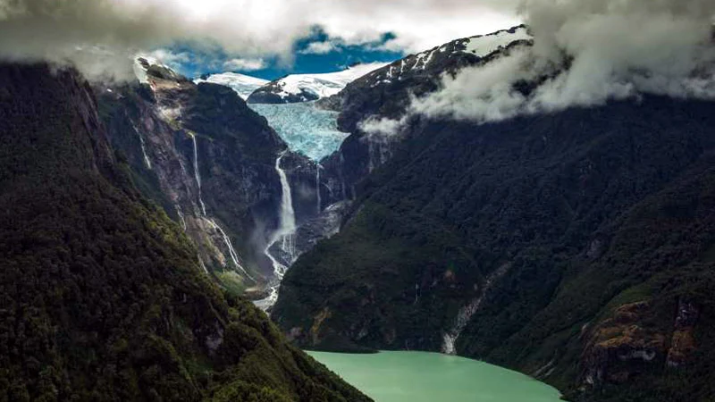
| © Photograph by Beth Wald Waterfalls cascade from a hanging glacier in Quelat National Park, a spectacular stop along Chile’s Route 7—also called the “Carretera Austral”—which winds through Patagonia. |
By Shannon Dell, National Geographic
Chilean Patagonia is a rugged region—isolated, wild, and ecologically diverse. Where else could you stand next to human-size rhubarb leaves, watching dolphins play in a fjord while impressive waterfalls cascade from the glaciers behind you?
To see it all would take years. But on a road trip down Chile’s Route 7—also called the Carretera Austral—you can pack the Patagonian adventures of a lifetime into a two-week journey. Here are our tips for the perfect road trip at the bottom of the world.
Before You Go
 |
| © Source: NG Maps |
Much of the 770-mile, north-to-south route connecting Puerto Montt and Villa O’Higgins is unpaved, so prepare for a bumpy drive. Though it’s possible to navigate the Carretera via public transportation or mountain bike, it’s best to rent a car and drive yourself during the summer (November to March), when more accommodations are available and it’s less likely that extreme weather will affect the roads.
 |
© Photograph by Beth Wald
A Chilean gaucho rides above Lago General Carrera, near Puerto Río Tranquilo. |
Brush up on your Spanish skills (or download a translation app) and pack your bags with gear suited for Patagonia’s notoriously windy days. Then head to Puerto Montt to stock up on food, repellent for mosquitoes and horseflies, sunscreen, and plenty of cash. While it’s possible to find groceries and ATMs along the way, you won’t meet another big town until 16 hours south in Coyhaique.
The First Leg: Volcanoes and Rainforests
From Puerto Montt, drive eight hours south to Chaitén, a volcano dormant for 9,000 years until a recent eruption in 2008 buried the nearby town in ash. The townspeople of Chaitén have since reconstructed part of the town and opened a three-mile, round-trip hike where visitors can overlook the volcano’s steaming dome and witness firsthand the death and rebirth of a forest ecosystem.
After Chaitén, head to Pumalín National Park, an area connecting the Andes with the fjords of the Pacific, to wander trails through the ancient Valdivian temperate rainforest.
After Chaitén, head to Pumalín National Park, an area connecting the Andes with the fjords of the Pacific, to wander trails through the ancient Valdivian temperate rainforest.
The Second Leg: Enchanted Forests and Hanging Glaciers
Three hours south of Chaitén lies Queulat National Park, famous for its jagged rock walls, hanging glacier, and glacial waterfall. After admiring the scenery from the shores of the lagoon, explore the mossy (and often muddy) bosque encantado, or enchanted forest.
For lodging and restaurants, make your way 25 minutes south to Puyuhuapi, a small fishing village tucked in a fjord alongside dense forests, misty mountains, and thermal springs. Enjoy a break with yerba mate, a traditional tea sipped from a gourd through a metal straw with a strainer at one end.
From Puyuhuapi, drive five hours to Coyhaique, where accommodation can be booked online ahead of time. Try pisco, a brandy made from fermented grape juice, before resting up overnight for the next day’s drive through arid and colorful mountains to Parque Cerro Castillo, a national reserve.
Tackle a strenuous hike through forests of Antarctic beech and lenga trees to reach the turquoise lagoon at the base of Cerro Castillo’s jagged peaks. Stay in the small, pioneer town of Villa Cerro Castillo or continue three hours to Puerto Río Tranquilo.
The last leg: ancient marble caves and glacier trekking
Puerto Río Tranquilo earns at least two days of your trip. Kayak through the General Carrera Lake’s Marble Chapels, a network of glacial caves veined with blue striations carved from calcium carbonate by over 6,000 years of water pressure. Or unpack your crampons to explore vibrant glacial caves on the Exploradores Glacier, one of the more affordable glacier hikes in Patagonia and only recently opened to the public.Drive 2.5 hours further south to find Valle Chacabuco. Use Valle Chacabuco as a rest stop—or hike the 14-mile Lagunas Altas Trail to spot guanacos and condors among the alpine lakes.
Finish the trek with an 8.5-hour drive to the isolated Villa O’Higgins, which marks the end of the Carretera Austral. Hop on a boat to cross Lake O’Higgins for impressive views of the O’Higgins Glacier, where you can sip a glass of whiskey chilled with ice from the glacier itself.
Travelers who chose to drive must turn around and retrace the road north. But those who journeyed by bike or public transportation have a couple options: Cross the lake into Argentina, hike to Laguna del Desierto, and grab a bus to the base of towering Monte Fitz Roy, or head south by boat to explore the Southern Patagonian Ice Field, the largest temperate ice sheet in the Southern Hemisphere.
![[feature] Take The Perfect Road Trip at The Bottom of The World](https://blogger.googleusercontent.com/img/b/R29vZ2xl/AVvXsEjy_fqQTqH44zYb1TqxvwzdMllFTvWsOLtU4iCu7kuU7sQDM1Lc6TE9bK2XTSZF0sdz4gKO7kaeM23DNXSoT9g_KNzqULd4b5wnkHLCfoKCYw3v5PqWrj86sl7qvIWwoqmYgRalsyWHTA4/s1600-rw/lifestyle.dearjulius.com.jpg)
Shannon Dell is a freelance writer from Tennessee on the constant hunt for the weird and wonderful. Follow her adventures on Instagram @strange_and_new.


